

October 2003
Read Regular
Juanjo Seixas writes in about Read Regular, a typeface designed specifically to help people with dyslexia read more effectively.
From the Read Regular Web site:
“Britain has two million severely dyslexic individuals, including some 375,000 schoolchildren. 10% of people using ‘Romance’ languages are coping with a reading difficulty. Dyslexia is a combination of abilities and difficulties that affect the learning process, displaying a wide range of difficulties. Dyslexia can occur despite normal intellectual ability and teaching, and it is independent of socio-economic or language background. The British Dyslexia Association
 There has been growing innovation to combat dyslexia, especially for children, in the form of computer software. However, relatively little design research has been done in the area of typography and type design that might support dyslexics. Read Regular is a typeface designed specifically to help people with dyslexia read and write more effectively.
Read Regular aims at preventing a neglect of dyslexia, creating a more confident feeling regarding the problems that occur with dyslexia.
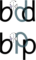
Read Regular is designed with an individual approach for each of the individual characters, creating difference in the actual characters of b & d itself (not mirroring the b to make the d), to create a large character differentiation.
The character shapes are simple and clear, creating consistency. The characters have been stripped down from all unnecessary details — such as a two storey a and a two eyed g.
The individual approach creates striking outlines that make sure that each character stands on its own and works together with its previous or next character. Used in the content of words, sentences and text, the following or the previous character does not try to interfere in its readability process. Ascenders (bdfhkl) and descenders (gjpqy) are long to ensure their legibility. Inner shapes for example within the o, e, a, u and openings in e and g are kept open to prevent from visually closing in. This makes Read Regular a friendly character and a pleasant balance between black and white.”
This story from Wired News talks a bit more about the genesis of the project.
Serve and Protect
From AP, August 26, 2002:
Florida police cars to sport corporate logos
“SPRINGFIELD, Fla. — This Florida Panhandle town is getting new police cars for only $1 each, but there’s a catch. The cars will be festooned with corporate sponsorship logos similar to those on race cars.
City commissioners voted 4-0 Thursday to accept the deal with Charlotte, N.C.-based Government Acquisitions. The company hopes to provide a new squad car for each of Springfield’s 15 officers within the next three years.
Government Acquisitions partner Ken Allison said advertising on cruisers destined for the Panama City suburb would be toned down.
Police Chief Sam Slay said the city could save about $500,000 over the three-year span.
‘You are talking about $500,000 that can be spent other places in the city, and that’s what this program is for,’ said Mayor Robert Walker.
Slay wants the savings used to hire two more officers, but Commissioner Carl Curti said other departments may need the money. Slay said his department should get to keep use the money instead of being punished for saving it.
Curti also was apprehensive about using the police car budget for other purposes.
‘These free cars may not always be free cars,’ Curti said.”
The Violence of Planning (and Its Resistance)
From Adrian Blackwell and Kanishka Goonewardena, Poverty of Planning: Tent City, City Hall and Toronto’s New Official Plan, in Planners Network, Winter 2003:
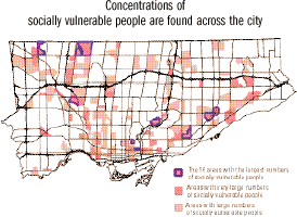 “While the [new official plan of the city of Toronto] represents a victory for the ruling classes of Toronto... some of the background documents prepared for the plan reveal traces of a struggle, even within City Hall. Toronto at the Crossroads, for example, includes a crystal clear map of the concentrations of ‘socially vulnerable areas’ in the city. It illustrates the growing economic polarization and pockets of poverty that form a ring running through the outer suburbs and around the inner city. Any reasonable official plan aiming to build a sustainable and equitable urban life would have started with these realities — the majority of existing people in the city — rather than banking on an exodus of dot.com millionaires and other pipe dreams of the ‘knowledge economy.’
The urgent question is this: What will happen to the various socially vulnerable groups in the city whose neighborhoods are either ignored in this plan or earmarked for gentrification?
The plan actually paves the way to remove people from strategic downtown neighborhoods, concentrating poverty in high-density suburban spaces whose reality is deliberately hidden in its three-lens vision. Complementing this violence of eviction is the alienating physical and symbolic violence constantly inflicted on individuals forced to live in these suburban spaces. These have a number of real effects.
- The physical distance between social classes protects affluent people from the violent power and frustration that economic exploitation creates.
- The physical separation prevents middle- and upper-class Torontonians from experiencing poverty firsthand, allowing them to indulge a fantasy of equality, while breeding stereotypes about people they don’t have to interact with everyday.
- Separation organizes the city so that affluent people have much better access to not only luxury goods, but also to essential services like healthy food, a clean environment, healthcare, public transportation, parks, public spaces and jobs.
- Isolation atomizes the very communities that could otherwise create unified resistance to this alienating condition. One of the lasting legacies of Toronto’s high-density modernist housing is that people are both concentrated and isolated from one another at the same time.
Real separation and isolation are symbolically overcome in the image of the beautiful city. The objective of urban design here is to mask beneath the spectacle of dazzling urban space the potentially explosive realities of the new amalgamated city of developers, taxpayers and global capital.”
The authors are members of Planning Action:
“A group of urban planners, architects and activists who work with diverse communities of Toronto struggling against economic, cultural, and ecological injustice to open spaces for people to imagine, transform, and enjoy the city.”
Their objectives:
- To collaboratively promote social and environmental justice by planning for affordable housing, food, public transportation, public space and accessible education and recreation for all residents and workers of the city.
- To democratize planning practice to foster greater participation and control over the creation and maintenance of the city.
- To build an organization that is committed to radically democratic and socially just practices within its own operation, in its partnerships and collaborations, as well as in the city.
Their work includes:
- popular education and outreach;
- planning, design, and advocacy for individuals and communities marginalized from traditional planning and legal systems;
- promotion of participatory planning that creates alternatives to municipal, competitive, and corporate-driven planning practices; and
- public comment and criticism of development projects, international trade agreements, and city practices, plans, policy, and processes.
First Nations, Mapping
In an article for Wired News on activists using of video and imaging, Julia Scheeres notes:
“Around the globe, indigenous tribes are mapping their ancestral land boundaries using global satellite positioning systems to guard against depredations by local governments and private companies.”
The article points to the Aboriginal Mapping Network:
 “A collection of resource pages for First Nation mappers who are looking for answers to common questions regarding mapping, information management and GIS. It is a network where First Nation mappers can learn about what other native mappers are doing, and share their own experiences throughout the aboriginal community. The AMN has a British Columbia focus, but is not limited to this geographic region. It is intended to be used by any group who is active in aboriginal mapping, from the introductory level, to the advanced. It is a source for both technical information on GIS mapping, to general information relevant to decision makers.”
The main areas of activity are:
- The Web site and electronic newsletter with information on data sources, training resources, funding, and news.
- Publication of resources and “best practices.”
- Informal roundtable workshops and the annual international GIS conference where First Nations organize and present mapping issues on First Nations terms.
The site’s extensive gallery hosts maps illustrating traditional territories, current boundaries, boundary disputes, traditional place names, environmental classifications, and cultural and ethnographic data — including some from pre-contact eras. Some good links, too, pointing to other sites with maps and mapping resources by and for Aboriginal peoples.
In June, the International Forum on Globalization’s Indigenous Peoples and Globalization program published a map depicting the negative impacts of economic globalization on indigenous peoples.
For another overview of the AMN, see Benjamin David Johnson’s 1999 thesis, The Aboriginal Mapping Network: A Case Study In The Democratization of Mapping:
“Critical mapping theory suggests that maps are subjective documents that implicitly but powerfully articulate the agenda of the culture that created them... Further, the interests portrayed on conventional maps are almost exclusively those of the dominant groups in society. It will be argued in this thesis that the Aboriginal Mapping Network provides a means to develop mapping skills in First Nations communities, therefore leading to the creation of maps that convey alternative visions of reality. These maps can be used in the planning process to counterbalance what John Forester (1989) would suggest is the ‘misinformation’ inherent in conventional maps....
Capacity building in GIS technology, it is argued, will allow First Nations to produce unconventional maps that articulate local worldviews and perceptions of place. As embodiments of local knowledge, these maps will in turn be used in planning, negotiations and governance to empower First Nations on their own terms.”
Design against Corruption
Let’s say the president of your country is corrupt. Let’s just say.
 The legislature is corrupt. The court system, police, and military are all corrupt. The city officials? The big businesses? They’re corrupt, too.
They misuse their power. They thrive on favoritism and get rich on kickbacks while the rest the country slowly starves. What do you do?
Replacing one individual with another doesn’t change the broader system or take away any of the incentives for corruption.
So how do you reduce corruption throughout a given system?
Transparency International is a network of independent national chapters that work to curb “both the supply and demand of corruption.”
Some of the strategies they use are described in their annual Corruption Fighters’ Tool Kit. The manual is just one of the ways the TI chapters share ideas with each other and offer their experience to the world at large. In addition to the hard work of organizing and building coalitions, many of the corruption-reducing strategies incorporate graphic and interactive design. Some of them include:
- Awareness Raising - TI Korea produced posters, videos, and CD-ROMs to disseminate information about the effects of corruption and local initiatives against it. TI Morocco indexed, cataloged, and analyzed incidents of corruption that appeared in the media, published their findings and will soon make this database accessible online. As part of its campaign to promote access to information in Romania and the Federal Republic of Yugoslavia, TI Romania produced and actively updated a Web site on the issue, printed a pocket guide to inform citizens about their rights, and designed posters and flyers with their Serbian partner organization to promote the idea of free access to public information and raise public awareness about the project. The posters were printed in Romanian and Serbian and distributed through an international network of NGOs and local government offices.
 Monitoring Election Campaigns - TI Chile developed and distributed a report card to tabulate the quantity, subject, and context of media coverage devoted to each candidate. They distributed their analysis and data on CD-ROM.
- Opening Processes - Activists in Lebanon determined that construction was the most corrupt sector in the country and designed a manual on how to acquire a construction permit, “one of the most difficult bureaucratic transactions in the Lebanese administration.” In response to the government’s lack of reliable information on the process of public procurement, TI Ecuador created an Web site to inform the public (and the private sector), make government forms available, display past and current bidding processes, and host a forum for discussion and analysis.
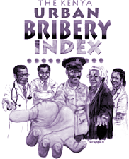
- Implementing Diagnostics - TI chapters in Bangladesh, Kenya, and Japan developed surveys and metrics for corruption in government and the private sector that they then published locally. TI Lithuania created a database of institutional and geographic aspects of corruption and published a “Map of Corruption” as a foundation for future campaign work.
Public Design, Year 868
From Democracy and Its Global Roots, by Amartya Sen:
 “In the subject of public discussion and communication, it is also important to note that nearly every attempt at early printing in China, Korea, and Japan was undertaken by Buddhist technologists, with an interest in expanding communication. The first printed book in the world was a Chinese translation of an Indian Sanskrit treatise, later known as the ‘Diamond Sutra,’ done by a half-Indian and half-Turkish scholar called Kumarajeeva in the fifth century, which was printed in China four and half centuries later, in 868 C.E. The development of printing, largely driven by a commitment to propagate Buddhist perspectives (including compassion and benevolence), transformed the possibilities of public communication in general. Initially sought as a medium for spreading the Buddhist message, the innovation of printing was a momentous development in public communication that greatly expanded the opportunity of social deliberation.
The commitment of Buddhist scholars to expand communication in secular as well as religious subjects has considerable relevance for the global roots of democracy. Sometimes the communication took the form of a rebellious disagreement. Indeed, in the seventh century Fu-yi, a Confucian leader of an anti-Buddhist campaign, submitted the following complaint about Buddhists to the Tang emperor (almost paralleling the current official ire about the ‘indiscipline’ of the Falun Gong): ‘Buddhism infiltrated into China from Central Asia, under a strange and barbarous form, and as such, it was then less dangerous. But since the Han period the Indian texts began to be translated into Chinese. Their publicity began to adversely affect the faith of the Princes and filial piety began to degenerate. The people began to shave their heads and refused to bow their heads to the Princes and their ancestors.’ In other cases, the dialectics took the form of learning from each other. In fact, in the extensive scientific, mathematical, and literary exchanges between China and India during the first millennium C.E., Buddhist scholars played a major part.”
Accordingly, the ‘Diamond Sutra’ scroll was dedicated to the public domain. From The Invention of Printing in China, by Thomas Carter, 1955:
“The book consists of six sheets of text and one shorter sheet with woodcut, all neatly pasted together so as to form one continuous roll sixteen feet long... At the end, printed into the text, is the statement that the book was ‘reverently made for universal free distribution by Wang Chieh on behalf of his two parents on the 15th of the 4th moon of the 9th year of Hsien-t’ung.’”
via Three-Toed Sloth and Lawrence Lessig
Mapping the State of the World
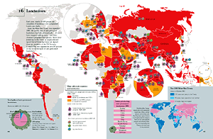
Myriad Editions specializes in one type of book: thematic atlases on economic, political, and social trends. The State of the World thematic atlases are full of maps, tables, cartograms, and other infographics that make global issues accessible at a glance.
The first State of The World Atlas was published in 1981 by Pluto Press. It was co-edited by Ronald Segal and Michael Kidron, until his death in March 2003. The book can be seen as part of his attempt to understand and write about capitalism on a global scale. The War Atlas followed in 1983.
Myriad’s list of titles includes:
- The State of the World Atlas (now in its 7th edition)
- The Atlas of War and Peace
- Atlas of Women in the World
- The State of Religion Atlas
- The State of the Environment Atlas
- The Atlas of Endangered Species
- The Atlas of Food
- The State of Health Atlas
- The Atlas of Human Sexual Behavior
- The Tobacco Atlas
- The Penguin Atlas of Media and Information
- and The Atlas of the Future
Individual countries atlases have been published on China, the USA, Germany, and France.
Coming soon: The Water Atlas and Atlas of the Middle East.
See some sample maps and their project for UNICEF illustrating the state of the world’s children.
They’ve done a couple of interactive, online maps for other organizations, too.
At Least the Trains Ran on Time
From snopes:
“One of the best ways to gain the support of the people you want to lead is to do something of benefit to them. Failing that, the next best thing is to convince them that you have done something of benefit to them, even though you really haven’t. So it was with Benito Mussolini and the Italian railway system.
 After the ‘march on Rome’ (which was itself a myth of fascist propaganda) on 28 October 1922 that resulted in King Vittorio Emanuele’s appointment of Benito Mussolini as prime minister and the accession to power of the fascists in Italy, Mussolini needed to convince the people of Italy that fascism was indeed a system that worked to their benefit. Thus was born the myth of fascist efficiency, with the train as its symbol. The word was spread that Mussolini had turned the dilapidated Italian railway system into one that was the envy of all Europe, featuring trains that were both dependable and punctual. In Mussolini’s Italy, all the trains ran on time.
Well, not quite. The Italian railway system had fallen into a rather sad state during World War I, and it did improve a good deal during the 1920s, but Mussolini was disingenuous in taking credit for the changes: much of the repair work had been performed before Mussolini and the fascists came to power in 1922. More importantly (to the claim at hand), those who actually lived in Italy during the Mussolini era have borne testimony that the Italian railway’s legendary adherence to timetables was far more myth than reality.
The myth of Mussolini’s punctual trains lives on, albeit with a different slant: rather than serving as a fictitious symbol of the benefits of fascism, it is now offered as a sardonic example that something good can result even from the worst of circumstances. As Montagu and Darling wrote:
‘Mussolini may have done many brutal and tyrannical things; he may have destroyed human freedom in Italy; he may have murdered and tortured citizens whose only crime was to oppose Mussolini; but “one had to admit” one thing about the Dictator: he “made the trains run on time.”’”
Fed Up with The Front

Since 1991, Ras l’front (“Fed up with the Front”) has campaigned against Jean-Marie Le Pen and his extreme right-wing party, the National Front. Ras l’Front collectives are active in cities throughout France.
See this collection of their posters on racism, fascism, sexism, immigrant rights, and other issues.
Uncle Sam
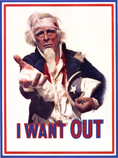
From the Committee to Help Unsell the War, 1971.
Download the image above as a 782 x 1024 pixel TIFF (2.3 Mb) from the Library of Congress.