

subway
Nothing Like the Sun
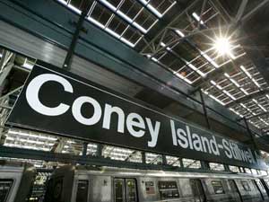
On October 28, Wired ran this bit on NYC’s new solar powered subway station:
“On a sunny day, 60,000 square feet of integrated solar paneling on its roof can generate 210 kilowatts of power, enough to meet two-thirds of the station’s energy requirements. The solar energy doesn’t run the trains, but is expected to contribute approximately 250,000 solar kilowatt hours per year to the station’s other energy needs — primarily lighting and air conditioning in the station and its attached offices and retail stores....
In addition to the Stillwell station, photovoltaic, or PV, cells help power a bus terminal and rail yard in Queens, as well as the Whitehall Ferry Terminal at the southern tip of Manhattan.”
OK, pretty cool. (But are we subsidizing those retail stores? Or are they paying the MTA for the juice?)
And of note is this little factoid:
“Total renovation costs approached $300 million, though it’s not clear how much of that came from expenses related to the solar roof.”
OK, pricey, but these things stick around a while. And of course, there’s the MTA’s $1 billion dollar surplus this year.
But it all puts into further context the MTA’s last minute demand that pushed the union to strike.
From today’s NY Times we learn that in the final minutes before the midnight deadline for negotations, the MTA changed their “final offer”, and pushed a demand to cut the wages of new workers by 4 percent. The plan would have the union win current benefits at the expense of future members (a classic tactic of employers negotiating with unions) and save less than $20 million over three years:
“less over the next three years than what the New York City Police Department will spend on extra overtime during the first two days of the strike.”
RNC Recap
A friend has graciously permitted me to post his recap of RNC week:
“My dears Al and Mrs. S., ever the social workers, were eager to join me on Friday night’s Critical Mass bike ride. At Union Square, several of the farm vendors decided, perhaps in leu of the overwhelming crowds, to give away their end-of-day produce and baked goods. So, as the numbers of cyclists grew exponentially, we enjoyed watching the kids, who looked more at home on an Earth First commune than in front of Republic, as they heartily chomped on the raw sweet corn and warily sniffed the fresh muffins for signs of dairy.
As we peddled off (reminding me of the gnarled-metal cycle-density of Shanghai biking), we received applause from plenty of 14th street bystanders. By the time we got to Houston, the sun had set, and the bike ranks had ribboned along Broadway so we had to be wary of cabs darting past and around us. But as we began to again amass up Sixth Ave, tensions (which i’ve known too well as an ACT UP marshall for so many years) from snarled and snarling motorists inconvenienced by the rally grew ugly. Clearly, no police arrangements had been made, making this a potentially dangerous action, further worsened by inexperienced young cyclists who were aggressively flinging their bikes (and only pair of legs) into the paths of vehicles. Enraged drivers bolted out of their vehicles, one block after another, and we elders intervened in several separate potentially violent confrontations. Fortunately serious violence was assuaged, but not without seeing the cyclists, in a number of incidents, being uglier and more aggressive than the SUV drivers. By the time we got to 23rd street, the random arrests had begun. The event had successfully vilified cyclists to many drivers and police
I missed NOW’s CODE RED March over the Bridge — the photos of my beloveds, the CHURCH LADIES FOR CHOICE looked great. I made it to City Hall for the end of the Rally; the most stunning rally sound-bite take-away for me was learning that 40 million women who were eligible to vote in 2000 didn’t.
As the NYC Sanitation trucks moved in, i could not fathom why the organizers didn’t insist that the many, many thousands of people at the rally take the many thousands of expensive printed protests signs, fold them into their bags and make damn sure they were visible up all over town the entire week, and in windows through November.
Saturday evening brought thousands of bells and their owners to “the socket” and the utter bewilderment of puzzled Ground Zero pilgrim/tourists and vendors [photos]. The Calatrava “temporary” entrance to the PATH trains became a pagoda for the bells, where volunteers gave us programs that looked like LIRR train schedules. intending to ‘orchestrate’ the event, with the occasional hissing of Buddhists who were angered by gentle nearby conversation, created a soundscape only defiled later by a guy who worked the city the whole week with a big Freddy Phelps-like scroll of a sign quoting some scripture confirming why we must vote for Bush. Upon his arrival, the press was no longer interested in Pauline Oliveros’s ambitious memorial: the jingle bells, Tibetan bells chimes, and at least one industrial lampshade being thumped like a muffled gong.
The THOUSAND COFFINS affinity group at the big march was in need of help. So we helped, finishing a few pre-fab die-cut cardboard coffins, draping them with flags (black bunting for unknown soldiers), then committing to the intense heat of the next six hours. It doesn’t take much crowd-estimation expertise to conclude that a mere 100,000 people would have taken over six hours to march the 42 block route. I yearned for a rally, chock-full of speakers (many with issues that, while unrelated to the war, would still not be even voiced if the Republicans had their way), But the gigantic rally was amazing, in it’s disjointed groups; and you couldn’t help but marvel at the thoughtully engineered, underestimated march attendee counts from the press ‘n’ state.. But silently walking the coffins was a meditative way to participate. No Central Park picnic for our procession, we got to Union Square around 6 p.m., quietly dissembling the coffins and folding the flags, looking more saddened than defiant.
Although looking out my window Tuesday night I couldn’t tell if anyone else intentionally illuminated their windows, I struggled to sleep under a “What’s My Line” airline sleep-visor in my brilliantly illuminated bedroom. I had dutifully followed Milton Glaser’s request and put a ‘light’ in my window. Having recently acquired one of the ubiquitous rainbow WE THE PEOPLE flags, I taped it up in my window over Broadway, with my art projector aimed at it all night : Spent Nuclear Fuel Rods for Peace...
Throughout the week, every time i ventured outside, i wore a 8.5” x 11” repro of the great Plaza Hotel TRUTH -> <- BUSH banner mounted to foamcore and gold cord around my neck. I tended to avoid eye contact and wore a tie most days. Many people approached me all week, as inspired by the banner as i was.
Due to a work commitment, on Thursday, I was on the uptown (2) train pretty-much directly under Madison Square Garden while W was speaking: after all the overtime, there was zero security on the subway or platforms; people on the train laughing — having clearly just heard or participated in shouting “FUGEDDABOUTIT!” as Al Franken had proposed.
Friday morning, off to the GM building plaza, with an enlarged poster of the great Plaza TRUTH -> <- BUSH banner. CNN was interviewing what appeared to be high-school boys in tee shirts with “one-eyed pirates” for a liquor company. As i was manhandled off the property, they kept growling “No politics HERE, No politics HERE.” And I foolishly shrieked about how having young kids advertising booze was Highly Political.
During the week, the event that got the least press was the media march from the CBS building to FOX [photos]. I printed out a long tall (conventioneer’s) sign that read BAN 527’s / BEGIN WITH FOX. People laughed, but it was too cryptic to make the evening news. In fact, the only press i saw for the event was of Miss Understood and Lady Bunny who stormed the rally in Grand Drag... good for them! Motherfuckers.
Then, in a blink of the shutter, the RNC circus left town.
Jamie Leo, reporting.”
GIS and the City
On February 6th, 2004, Al Leidner, former head of New York City’s Department of Information Technology and Telecommunications GIS Program, spoke to members of GISMO about the future of geographic information systems in New York City.
A version of this program was originally presented to the Municipal Data Processing Council. I’ve combined my own notes below with those taken by James Labate.
The GIS Utility: Key Integration of IT
- GIS marries information technology with the science of geography.
- The value of information has become the center point of the industry: the quality, amount, and how integrated it is.
- The technology is there, but the data is lacking. The more combinable data is, the more valuable it becomes. To that effect, the “stove piping” of information is a massive problem.
- From Data to Wisdom: Increasing the value of data should be the goal of the GIS Community.
- The “Where Field” - Geography as an ancient science vs. IT as a new industry. GIS people need to bring geography to IT people.
- We’re still in the early stages of understanding the integration of data. But all data is spatially enabled and therefore can be combined. For example, an automated mapping application can plot a database of 500,000 tree locations off of building and other feature locations.
- Five basic fields on NYCmap, the City government-maintained basemap, are: postal address, latitude and longitude, street segment, parcel, and building. These are all related and identified with a unique ID.
How Do We Create Value?
- With a “critical mass” of data support to NYCmap.
- The Department of Health used a “critical mass” of West Nile identifiers (e.g. infected birds) to created a predictive model of West Nile Disease. (A series of maps were shown depicting the spread of the virus.) Using the maps, they could quickly spray selected areas. Human cases are preempted. Predict death and stop it. GIS can save lives.
- In 9/11, the NYC Office of Emergency Management lost its office and data when the towers collapsed. Responders to the disaster needed combinations of data. GISMO volunteers and others provided data to responders from an ad-hoc office at Pier 92. Speed and ability to deal with complex interactions were key features.
- City’s 311 non-emergency hotline uses a GIS engine which geocodes all data that is taken in. With this, can look for patterns and trends in neighborhoods. (Do trash dumping complaints predict a rise in crime?) The City recently mapped cell phone outages using survey info from 311 and the DoITT Web site.
- My Neighborhood Statistics at nyc.gov, and CMAP’s myCiti expand the knowledge of GIS among non-GIS professionals.
- 40 City, 35 State Agencies create knowledge from GIS data. (See notes on Al’s GIS Coordination Program).
New Developments
- Massive sewer and water system mapping project underway.
- Dept. of City Planning releases geosupport desktop application.
- COGIS - developing better property tax lot outlines.
- Homeland security driving Federal, Local GIS integration.
- FDNY, EMS, NYPD integrating exchange of data for emergency response, sharing with State, FBI.
- Modeling building and subway systems for emergency response. 468 stations in MTA. PATH and Amtrak next.
- Aerial photos, from Pictometry, show all sides of every building in NYC. Free to City agencies.
Opposing the Future - Roadblocks to Progress
- Underfunded IT and GIS.
- Little understanding of the transformative process of IT.
- Contempt for Planning - Outmoded stereotyping.
Cultural Evolution
- What are the combinations of data across service and agency barriers that produce results?
- What are the analytic and predictive tools that can do it?
- Combine all capital projects - see where there are synergies, opportunities to overcome problems.
Benefits
- Revenue: better use of geography will create a higher level of billing accuracy, increasing City revenues.
Public Safety
- Develop an integrated 911. Fire Dept. and Police should be working off the best geocoding system possible to improve response time, plot fastest routes to sites.
- CompSTAT - Police Dept. Application - GIS saving lives. Info and analysis brought together with new way of organizing. (See this BBC article on mapping crime.)
- Hazardous materials and combustibles: combination of previously uncombined data to give firefighters more information before entering a building.
Predictions
- Every City agency will have GIS. Wireless connections to data applications from sites.
- 500% staffing increase in City GIS Personnel.
- Federal Govt. will need and seek out state and local data as it is more accurate and of a higher quality.
- Spatially enabled information will be the foundation of a 35% increase in productivity and 2% increase in revenues.
- All City strategic data will be available and the increase of shared valuable information will increase social cohesion and collaboration.
- Construction time will be reduced 10% and construction costs reduced 5%.
- Predictive models will reduce violent crime by another 50%.
Al noted that more and more City data is available online, though many in audience noted felt that the City does not share enough of its data. NYCMap is not available to the public for “security reasons,” but is licensed to a couple of Universities and corporations under strict terms.
See also “City Governments Map Trends” from Wired, February 1, 2004, and this 2002 interview with Al about GIS and the emergency response on September 11, 2001.
Nonprofit Online Mapping in New York City
Steven Romalewski sends this growing list of nonprofit online mapping Web sites in New York City:
“We’ve noticed a kind of a critical mass of these mapping and data services recently.
 Most of these have been created by my project, NYPIRG’s Community Mapping Assistance Project (a team of six people, part of a nonprofit organization, that uses GIS to help other nonprofits achieve their missions). They’re all part and parcel of an effort to ‘democratize’ data and provide powerful new tools with a community-based focus. Each site uses GIS technologies that few other nonprofits have tapped into, but that government agencies and the private sector have used to great effect. The websites use government data in in new and innovative ways, often to provide services that most government agencies would never provide. And they give local neighborhoods and individuals a window on their world that would’ve been daunting, at best, and maybe impossible for the average citizen or block association to obtain. The sites have helped level the ‘playing field’ in New York to a great extent, so public agencies and large companies don’t have a monopoly on information.
Here are the links:
- http://www.MyCITI.org — the Community Information Technology Initiative (CITI) website that puts mapping tools in the hands of New York City’s local planning boards, in a way that they can avoid the need to spend limited resources and duplication if all 59 boards had to buy the software and invest in the data creation themselves;
- http://www.oasisnyc.net — a wealth of information about parks, wetlands, gardens, and other open spaces across New York, reaching across all levels of government and developed for all different aspects of the city’s ‘greening community’. This site was spearheaded and funded by the US Forest Service, and involves a steering committee of more than 40 nonprofits, government agencies, academics, and businesses;
- http://www.nonprofitmaps.org/netmaps/bedc/bedc.htm — the Brooklyn Economic Development Corp’s. ‘Destination Brooklyn’ service that offers detailed real estate and demographic information for every property and neighborhood in Brooklyn, geared toward small business owners and community development organizations;
- http://www.straphangers.org/cmap.php — the Straphangers Campaign’s ‘Get Where You’re Going’ site, providing precise location information about the subway stops closest to any street address in NYC (which the MTA’s maps can’t do, since they’re geographically distorted to fit on a printed page);
- http://www.MyGovernmentNYC.org — allows anyone with a New York City address to easily find and contact the public officials who represent them at all levels of government, and is used by thousands of people each month, regularly praising it for its simplicity and comprehensiveness;
- http://www.nonprofitmaps.org/netmaps/lac/lac.htm — how to locate family literacy programs based on a survey by the Literacy Assistance Center, mapped by category, borough, or ZIP Code. The site also shows nearby subway stops and public libraries;
- http://www.nonprofitmaps.org/nycnonprofits — the NYC Nonprofits Project Service Atlas. It extends a 3-year study of the nonprofit sector that was released in June 2002, by enabling you to locate any of more than 6,000 nonprofit groups in the city by ZIP Code, neighborhood, Community Board, or City Council district. Groups are listed in 17 major categories and lots of sub-categories. CMAP created the Atlas for the Nonprofits Project; and
- http://www.LowerManhattanMap.com — helping with the recovery and rebuilding efforts of lower Manhattan small businesses, tourist destinations, and cultural organizations. The site includes information maintained by 3 business improvement districts on almost 2,000 local businesses, retail stores, restaurants, community services, cultural sites, and tourist attractions.”
Repurposing Payphones
The Washington Post reports on the demise of the payphone:
“In Washington, as in other parts of the country, pay phones are disappearing from the landscape. The number of them across the country has dwindled from a high of 2.7 million in the mid-1990s to about 1.9 million now, supplanted by the more personal wireless phones that fit in a pocket. The small companies that maintain them are pulling out of the business. Even at the higher price of 50 cents a call, many phones run at a deficit — it costs more to clean, maintain and service them — so people like [technician Andres] Castro are yanking them from their sockets, cutting the lines, and pulling them from shopping centers, gasoline stations, restaurants and street corners where they used to turn a booming profit.”
The Globe and Mail reports that instead of dismantling its pay phones, Bell Canada has started adding WiFi capabilities:
“Aimed at business customers, the service is free until late March and available at several sites in Montreal, Kingston, Ont., and Toronto. The project will also include service at Air Canada airport lounges in Calgary, Montreal, Toronto and elsewhere. The pilot project is intended to measure how customers use the service and how much to charge for it, although some observers wonder if service providers will be able to make much money from so-called wireless fidelity or wi-fi hot spots. For Bell’s hot-spot trial, it’s mostly setting up wi-fi nodes where it has payphones, effectively ‘reinventing’ the payphone business.”
In the United States, massive amounts of cash are being thrown at building a nationwide wireless infrastructure. Adding WiFi to payphones is picks up on an exisitng infrastructure. From Bell Canada’s press release:
“The plan calls for payphones in high traffic areas to be fitted with Wi-Fi technology; typical locations include airports, train stations, hotels, convention centers and corporate campuses.”
Adding WiFi to payphones would be a good way of brining WiFi to underserved neighborhoods — the same neighborhoods that rely on pay phones rather than cell phones.
From the Post again:
“It is much easier — and cheaper — to dial from a cell phone for customers who can afford one. However, pay phones are still profitable in the lowest-income areas of a city, said Terry Rainey, president of the American Public Communications Council Inc., an industry group representing independent pay phone operators around the country.
‘There are a great number of people in this country without a phone,’ Rainey said — 4 and 5 percent, which is more than the 1 or 2 percent of the U.S. population that lacks television sets.
‘Some lower-income areas rely on [pay phones] for regular communications, as well as, in some cases, emergency calls,’ said Mason Harris, president of Robin Technologies and of the Atlantic Payphone Association.”
Compare this map of median household income from the 1990 U.S. Census with this 2002 map of WiFi hotspots in Manhattan. From the Public Internet Project:
Click here for a larger version.
Update: On May 10, 2003, the New Jersey Star-Ledger reported that Verizon plans to put WiFi transmitters in pay phones across New York City. No mention of how much it will cost to use.
Also of note is this May 5 article from the International Herald Tribune which describes plans by the city of Paris to build a WiFi network along the subway system. Two or three antennas could be places outside each of Paris’s 372 Metro stations.
Design Against the War
Over a year ago I attended a lecture on design at the Cooper Union. The speaker projected a series of slides illustrating his minimalist design philosophy. One of the images was of the B-2 bomber. I was shocked and disturbed that a design philosophy would fail to take into account social, political, and economic contexts. Particularly of an object which, when used as intended, delivers massive death and destruction.
It prompted me to dig deeper into design and the public interest. And to start this Web log.
On evening of April 16, I arranged a panel discussion at Cooper titled “Design in the Public Interest / Design Against the War.” I invited three panelists to speak about their work as designers involved in the anti-war movement.
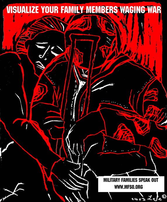 First up was Lee Gough, a printmaker, anti-war activist, and graphic artist based in Brooklyn, NY. She showed a series of prints from a portfolio-in-progress on the Iraq invasion and the war at home, called “The War Went Well.” Some of the images have been used in posters on the Web site Who Dies for Bush Lies“ and for Military Families Speak Out, an organization of people who are opposed to war in Iraq and who have relatives or loved ones in the military.
One image “Fight the War at Home” was inspired by a subway ride home from lower manhattan on September 11. Even as the towers had just been destroyed, there were still, as there had been for many years, homeless persons on the subway appealing to cityfolk to remember them, and to give. The image is a graphic reminder that some have been under domestic attack in our country for a long time, and that funds for the war on poverty pale in comparison to our “defense” budget. Another image, “Visualize Your Family Members Waging War” depicts a despondent soldier with a crutch being embraced by a woman. Lee’s expressive linocut style brings a gravity to the subject matter.
Lee commented on the challenges of choosing one’s message, for instance, noting the different context of “Bring the Troops Home” for troops that have been drafted vs. those who enlisted voluntarily.
One member of the audience raised the question of why U.S. flags and “being American” were the province of the pro-war movement, when large numbers of U.S. citizens were opposed to the war. I noted that I’d seen many anti-war demonstrators holding up flags and patriotism at rallies. On the Web, Who Dies for Bush Lies? effectively tackles effect of the war on U.S. soldiers and U.S. civilians, in addition to Iraqi soldiers and civilians. The danger was raised, though, of the rhetorical trap: the argument over who is “more American” can go back and forth forever, and quickly turning attention away from the crisis at hand.
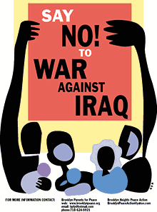 Nancy Doniger has worked as an illustrator for almost 20 years, producing art work for newspapers, magazines, books, posters and T-shirts for both for-profit clients and not-for-profit groups. She is currently a member of Brooklyn Parents for Peace, for whom she created the “Say No to War Against Iraq” poster.
She also helped organize a community/family oriented workshop that gave kids and parents an opportunity to make anti-war art for protest marches. Adults and kids made signs and worked with a puppeteer to create a large paper mache dove, and lots of little doves held aloft on cardboard tubes.
Nancy showed some earlier examples of her work, including a forceful image against the FTAA, a stark two-color poster for a conference on the conflict in Israel and Palestine, and a bright, celebratory “Welcome Back to Brooklyn” poster.
She also showed a couple of iterations of the “Say No to War” poster. One implied the damage of war with flames, but the final version ultimately centered on the mass mobilization. She noted that, in contrast to other illustrations, her work on this piece progressed from representation to geometric abstraction to make the poster more inclusive, using large blocks of color instead of specific depictions of race and gender. She is currently working on a “Hate Free Zone” poster.
Nancy noted the effect of the “Say No to War” poster on her block. The block appeared to be a very pro-war, where “the flags are quick to come out.” But over time, the “Say No to War” poster began to appear in windows and doorways. I certainly noticed it up and down the block where my step-sister lives.
Nancy is also involved in upcoming anti-war event “WEARNICA.” Sponsored by Brooklyn Parents for Peace, on May 3, 2003 a group of artists will present original anti-war art executed on the backs of white cotton dress shirts. The shirts will be worn in public spaces around New York and the world. The event was conceived by Works on Shirts Project whose inspiration for the event came after Colin Powell insisted upon covering the tapestry of Picasso’s Guernica during his warmongering speech to the General Assembly of the United Nations on February 5, 2003.
L.A. Kauffman is a staff organizer for United for Peace and Justice and designer of materials to promote the February 15 and March 22 marches in New York City. Her sticker and poster designs United for Peace and Justice can been seen on the streets across the New York City.
Leslie arrived at design through her work as editor of a progressive journal. She was inspired by the bold, clear graphics of Gran Fury and ACT-UP, and the use of those graphics on the street and at demonstrations, stage managing the events to push its imagery into the mainstream media. She claims she can not draw, so uses clip art in her graphics. The image of the blue pennant flag and black group have become a ubiquitous the city streets.
The idea behind a worldwide day of anti-war marches came out of the European Social Forum held in Florence this past November. At the Forum, the date February 15 was chosen as a date for anti-war demonstrations “in every capital.” What transpired was unexpected and unprecedented.
United for Peace and Justice had only just formed in the November of 2002, but it wasn’t January the group started working on the February 15 march. 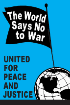 “The World Says No” was the headline of the February 15 flyer design, accompanied by a list of cities taking part in the event. As news of the event travelled across the Internet, marches were planned in more and more cities. Leslie held up various versions of her February 15 design with more and more cities added. Ultimately, marches were held in 793 cities around the world on February 15. Of particular note is virtual absence of communication or coordination between the participating cities.
Leslie spoke of the focused purpose of the posters produced for the event: not to educated, but to mobilize. The flyers lack all superfluous text or argument, just the headline, time and place. The posters and stickers were not trying to change people’s minds, instead to reach out to people who were already against the war but had not yet taken action.
In addition to sticker and flyers, palm cards cut from 1/4 page xerox copies on blue paper were popular and successful. They are both cheaper and more effective — easier to stuff in your pocket, less burdensome on the counter tops of sympathetic shopkeepers.
For the February 15 march, 200,000 stickers were distributed in 5 weeks. For the March 22 march, 200,000 stickers were distributed in 3 weeks. Astonishing numbers, posted around town by a continual flow of volunteers through the office. It’s also a useful bench mark: this is how many it takes to spread the message. A month later, I’m still finding remnants of UPfJ stickers on walls and phone booths. Leslie noted the effect of thousands of little acts of civil disobedience for the spirit of protestors, slowly bolstering a spirit of resistance around in the City and specifically, against the police department ban on marching past the U.N. on February 15.
In total, 1.1 Million pieces of literature distributed. Almost all of the printed materials were bilingual: English on one side, Spanish on the other. However, materials were also produced in Korean, Spanish, French, Creole, and Chinese. Quite a few donations for all these production expenses came online via paypal.
The question was raised about the environmental impact of producing all those printed materials. Her response: it’s also better for the environment if the war is prevented.
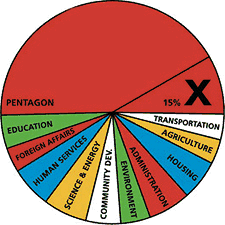 Other examples of design projects were raised by members of the audience: a “Do Not Bomb Iraq” sticker to replace the “Do Not Lean On Doors” sticker in NYC subway cars; colorful logos, charts and imagery designed by Stefan Sagmeister for “Move Our Money,” a campaign to reallocate 15% of the U.S. military budget for education; and flyers handed out to tourists at ground zero with a graphic representation of the number of teachers aides that will be cut from City’s budget. The image leaves it to the viewer to make to the connection to the military expense of a war in Iraq.
Many spoke of the importance of New Yorkers being seen as against the war. September 11 was an attack on New York, and the war is being waged in our name. Others spoke of the urgency of independent media, and the challenge of reaching out beyond “preaching to the converted.”
Overall, I was struck by how spontaneous the designers’ actions were. In almost every case, the designers simply stepped forward and got involved: signs made for a rally were eagerly snapped up; hundreds of thousands of stickers eagerly taken and distributed; and, “Say No to War” posters popped up on an otherwise apparently pro-war street. It seems that one doesn’t necessarily have to change everyone’s minds. There are more “converted” than you think. They just don’t have the graphic materials to display yet.
About 50 people came to the event, a decent turnout despite the announcement from the Pentagon the previous day that “the major fighting” in Iraq was over... and the fact that I’d scheduled the event on the first night of Passover. (Such a Jew am I.) The arc of the event could have used a better closing at the end, as well as a better transition between panelists. I also noted the lack of diversity in the audience. I think next time, I should hold it at different time and place. I’m also quite pleased with the invite design. Peel off the event description and you’re left with an anti-war sticker. Many thanks to Photobition for helping hammer this out in time.
One purpose of the event was to connect artists, designers, and activists. I’m disappointed more Cooper students didn’t show, but after the event quite a few people milled around having these intense little conversations until I kicked everyone out to close the room and return the lights. And quite a few people asked me what was next. Perhaps the start of a new Committee to Unsell the War?
Together for the City We Love
![]() In February 1975, New York City reached the nadir of its financial crisis when underwriters withdrew from a $260 million bond issue, putting the the City on the verge of insolvency. To help generate income, the New York Commerce Commission hired ad agency Wells, Rich and Greene to develop a campaign that would promote New York City and state as a tourist destination. The slogan they came up with: I Love New York. The Commission hired designer Milton Glaser to develop a logo. When the ads came out in 1977, they featured New York celebrities including Frank Sinatra, Morgan Fairchild and Yul Brenner.
In February 1975, New York City reached the nadir of its financial crisis when underwriters withdrew from a $260 million bond issue, putting the the City on the verge of insolvency. To help generate income, the New York Commerce Commission hired ad agency Wells, Rich and Greene to develop a campaign that would promote New York City and state as a tourist destination. The slogan they came up with: I Love New York. The Commission hired designer Milton Glaser to develop a logo. When the ads came out in 1977, they featured New York celebrities including Frank Sinatra, Morgan Fairchild and Yul Brenner.
The campaign was an enormous success, running for 25 years, with no end in sight. (There’s certainly no shortage of fabulous I Love New York merchandise for sale around town.) The logo has become iconic and often imitated.
 In the aftermath of September 11, 2001, Glaser updated his design by adding a smudge to the lower corner of the heart and the words “More Than Ever.” The image must have struck a chord. It seemed to pop up in every shop window in town. Glaser, who’s taught design at the School of Visual Arts for 40 years, worked with the director of the school to print up posters. Students ran around handing out 5,000 posters, and New York’s papers reprinted the image for their readers to clip and post. Personally, I thought the image was corny, but a step up from all the flag waving. I did experience the incredible comradery of the people of New York City. Many, however, experienced incredible animosity and even violence.
At the bottom of the posters is text that specifically notes that the posters are not for sale. Glaser did make one exception, though, when he allowed WNYC, a public radio station, to sell posters to raise money to replace the broadcast tower and antenna that were destroyed when the towers collapsed. The gesture ultimately raised $190,000.
It’s a year and a half later and the city faces another financial crisis. Glaser has designed the third in a continuing series of messages: “Together for the City We Love.”
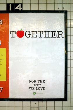 Glaser told the Daily News:
“His new phrase was inspired by the city’s fiscal crisis and the recent threat of a transit strike. Glaser sent City Hall several designs with the slogan, which he says could serve as a ‘rallying cry’ to help New Yorkers bond during tough times.”
When I first saw the new logo in the subway, I was skeptical. As a New Yorker, I will not be bullied into happiness or togetherness. Certainly, when the State sells unity, I wonder who stands to gain. “Community” is often used the gloss over difference and dissent. “You’re either with us, or against us.”
The design, however, is open to interpretation. One could just as easily use it at a block party or mass action. And I’m sure subway riders will note their own impressions on the ad’s generous white space.
As it turns out, the city chose not to use the design. Instead, Glaser and SVA will be publishing it on their own again — the public act of private individual, an educational institution, and its students. SVA also arranged ad space in the subways. The students will distribute the printed posters this weekend.
“The people of NYC seem to be losing that sense of cohesion we felt a year and a half ago,” says Glaser. He hopes the campaign will encourage people to be nicer to each other and may try to use it as a fundraiser for the City to help pay for some of the services being cut. “It’s a drop in the bucket, but it would have symbolic meaning.”
Meanwhile, the city government has plans of its own. Mayor Bloomberg has set up a permanent office and campaign to sell New York to big business and investors and to woo major events. The effort relies less on advertising and more on deals with the private sector and behind-the-scenes lobbying.
It has already brought back Grammy’s and next year’s WNBA All-Star game to New York, but also the Republican National Convention in 2004.
I for one will be out there protesting, together for the city we love.
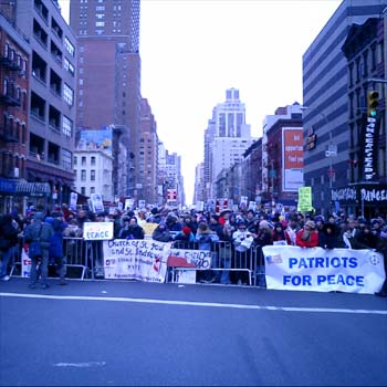
Under the Asphalt, the Cobblestones
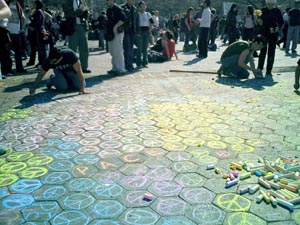
Protestors after the march in New York City yesterday chalked messages around Washington Square Park.
As the U.S. invades Iraq and activists around the world take to the streets, here in New York I’m noticing how the city itself is increasingly used as a medium by the anti-war movement.
 Much of this is nothing new. City streets have always been checkered with posters, graffiti, flyers, and stickers. Subway ads are often annotated with running commentary, sometimes sexual but just as often critical of the ad and advertiser itself (or just blacked out teeth on a too-cheerful model.)
 The anti-war movement has taken advantage of all of this. United for Peace and Justice stickers seem to be everywhere — on pay phones, mailboxes, street lamps, walls, and signage. The letters “STOP BUS” on the street are altered to read “STOP BUSH.” In the Baghdad Snapshot Action activists have simply postered ordinary snapshots from Iraq: “Quiet and casual, the snapshots show a part of Baghdad we rarely see: the part with people in it.”
And then there was the march of over 200,000 people down midtown Manhattan yesterday.
But as the war escalates, so do the protests. And so does the reconfiguring of public space. Activists in San Francisco last week shut down traffic throughout the city with autonomous direct actions coordinated online. Activists hauled newspaper kiosks, cafe chairs and tables, and other street furniture into the streets. [article and photos]
What will be the government’s response? Some communities are all too familiar with locked down, fenced in, and video monitored public spaces. Once considered an invasion of privacy, cameras and other measures are increasingly justified as a legitimate response to terrorism. In the name of anti-terrorism, the City recently sought and won a loosening of the law that restricted on police surveillance of political groups. The restrictions were imposed by the settlement of a 1971 lawsuit over harassment of political advocacy groups by the Police Department’s so-called “Red Squad.”
Public amenities and the details of public life are being reshaped elsewhere in the fight against terrorism. In Israel, seating at bus stops is often bolted to the wall (no chair legs to hide things behind), every turnstile will soon have a metal detector installed, and every trash can on the street will be replaced with see-through plastic and wire receptacle. In Washington, D.C., subway trash cans are being replaced with bomb-resistant models. In the Tokyo subway, there are no trash cans at all anymore.
Not to mention Israel’s wall.
This week New York City announced Operation Atlas, additional security measures to try to protect us against terrorist attack during wartime. I’m not opposed to greater inspection of cargo entering the City, but have no doubt that the NYPD will use their new powers to target activists and political dissent. I also note that the plan, which costs $5 million a week comes at a time of severe budget cuts in NYC — and a deficit of nearly $4 billion. Was factored into the costs of the war?
Literature on cities is replete with the metaphor of public space as the site and the physical embodiment of democracy. In the weeks and months ahead, I wonder how our public space will change.
See NYC IndyMedia and Gotham Gazette’s page on New York City and the War.
Routing
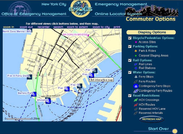 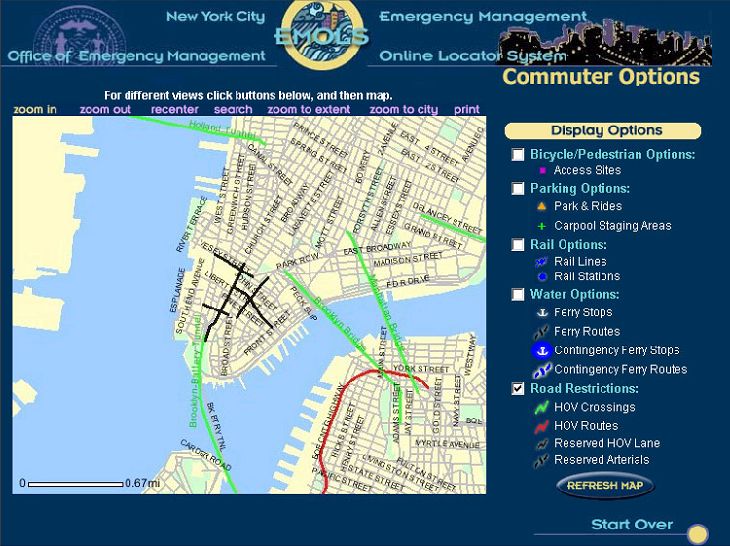 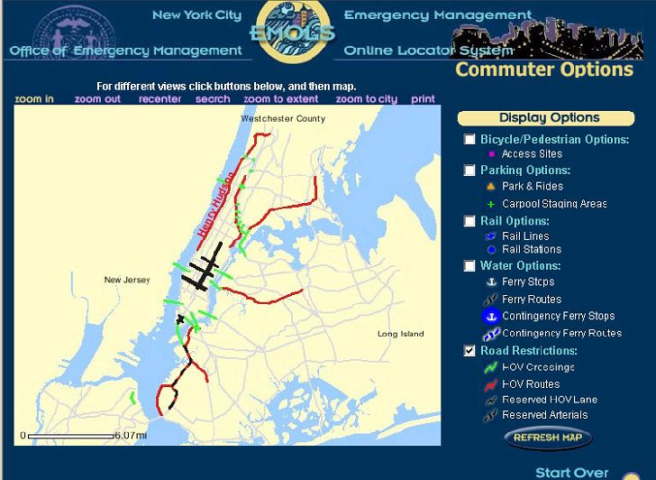 Click for a full size view. |
“New York City averted a public transit strike recently, saving commuters and residents a metropolitan-size headache of getting around. But if it had come to that, the city was ready to help idle people find their way.
A week before the scheduled strike, the city’s Office of Emergency Management, the Department of Information Technology and Telecommunications, and Frankfort, Ky.-based PlanGraphics Inc. designed and developed an interactive online map that enabled users to view various alternative transportation options and vehicular restrictions.
The application, which took about a half-day to design and a week to develop, was activated from Friday evening, Dec. 13, to Monday noon, Dec. 16, the deadline for the strike, said Mike Wiley, a project manager for PlanGraphics in New York City. During that time, users viewed more than 70,000 custom maps with a peak of about 6,000 maps served up Sunday evening. Although the application was subsequently deactivated, it’s available should a similar situation occur in the future.
The system can highlight bicycle and pedestrian access sites, carpool staging areas, rail lines and stations, ferry stops and routes, including contingencies, as well as carpool-only routes and other road restrictions.
The application is based on the city’s Emergency Management Online Locator System, which allows New Yorkers to find hurricane evacuation routes or cooling centers during a heat wave.
PlanGraphics, which has a seven-year working relationship with the city, also helped develop an online map of the area around the World Trade Center shortly after the Sept. 11, 2001, terrorist attacks. Sometimes twice daily, the company or the city would update what areas were accessible by motor vehicles or pedestrians in the area and provide other information.
The company is also planning to update the city’s “My Neighborhood Statistics” application, which allows users to view 14 selected performance statistics about their community, such as air and noise complaints, structural fires, infant mortality, clean sidewalks, felonies and certified teachers. By the end of January, the system, which went live in September 2002, will show 80 different metrics.
The city also recently awarded PlanGraphics a three-year, $15.4 million contract to continue to develop and upgrade the city’s GIS data repository, and provide greater access as well as more customized applications for the public and city agencies.”
Other non-interactive maps were posted, but the site vanished from the Web as quickly as it was posted.
MapQuest has driving instructions, Staphangers .org used to have a working subway route finder, and the Department of Transportation has PDF of NYC bicycle routes, but I’ve not found anything that ties together NYC’s many transportation alternatives into one online application.
In a struggle that shook the City, the Transport Workers Union stood up to the Mayor’s intimidation and successfully fought cuts. They also pushed the City into developing the most comprehensive New York City route finder I’ve seen. The screen shots I found indicate that the target audience were those who work in lower Manhattan and Wall Street, but such a tool would be useful for everyone — and would indicate which neighborhoods are underserved. I hope they put it back online, with subway and bus info added.
Update, 9/12/2003: The lack of a integrated route finding system in NYC has prompted one New York City resident to build his own. It needs work, but integrates bus and subway connections quite nicely.
Closing Song
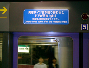
The first time I took the Tokyo subway system I noticed the lyrical little melody that announced that the doors were about to close. A sort of well-tempered Casio clavier running up the scales. I noticed it, but didn’t think much of it. It’s certainly more pleasant than NYC’s generic bing-bong sound, but is nothing to write home about. After all, lots of rail systems have some kind of audio cue. Then I heard the bossa-nova variation at the Harajuku Japan Rail station. Wow! That’s some funky stuff! It turns out different lines have different tunes. They also change the tunes periodically to keep people on their toes. Stay tuned to this station.